
Overview
- Housing and Homelessness Plan Annual Report link
- Most recent Official Plan
Asset Map includes the following within a 1-hour drive of the selected municipalities:
- Parks
- Schools
- Hospitals
- Arenas/Community/Rec Centres

- Population
- Population Change (2016-2021)
- Age distribution by Gender
- Households by size (1-5+ people)
- Single-parent households
- Number of owner households
- Number of renter households
- Number of households in band housing
Number of people on the by name priority list
A By-Names Prioritized List is a list of people experiencing homelessness in a community. It includes a robust set of data points that support coordinated access and prioritization at a household level and an understanding of homeless inflow and outflow at a system level. This real-time actionable data supports triage to services, system performance evaluation, and advocacy for the policies and resources necessary to end homelessness.

- Total Labour Force
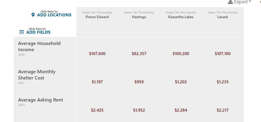
- Average Household Income
- Median Household Income
- Top Jobs by Industry
- Number of people in low-income status
- Median Individual Income
- Average individual income
- Unemployment rate

> Number of households spending 30% of income on shelter costs
> Average/median value of dwelling
> Monthly Shelter Costs
Average rent per month for 1, 2 and 3 plus bedroom apartments
.png)

- Housing Corporation-operated housing units
- Municipally-operated housing units
- Partnerships to supply attainable or affordable housing
- Number of Dwellings (single detached, semi, row, apartment & other)
- Number of housing in need of repair
- Monthly permit data

- Affordable housing Exemptions and Waivers
- Affordable housing Municipal Grants and incentives:
- Name of Municipal Grant or Incentive
- Amount (Eg. Dollar amount, full/partial tax incentive, etc...)
- The current status of Development Charges application
- Zoning Summary Table
- Residential Zoning Types and permissible builds
- Commercial/Industrial Zoning Types that permit multi-residential above
- Link to Zoning by-law
- Interactive Zoning Map
Zoning Map includes:
- Settlement boundaries
- Servicing areas
- Multi-dwelling zoning (3 or more dwelling units permitted).
The Community Comparison tool brings all data points and available locations on the RHIS into one easy table.
Other Resources
Data Sources and Definitions
The Data Sources and Definition page provides context about where the data within the RHIS is sourced and data methodology.
Tutorials
The Tutorial page includes videos about every page in the RHIS and how to navigate through the system effectively. A great reference as you learn to use the system.
- Français
-

Vue d'ensemble
- Lien vers le rapport annuel du plan pour le logement et les sans-abri
- Plan officiel le plus récent
.png)
- La population Évolution de la population (2016-2021)
- Répartition par âge et par sexe
- Ménages par taille (1-5+ personnes)
- Ménages monoparentaux
- Nombre de ménages propriétaires
- Nombre de ménages locataires
- Nombre de ménages dans des logements en bande
Nombre de personnes figurant sur la liste de priorité par nom
La liste par nom est une liste en temps réel de toutes les personnes connues qui se trouvent en situation d’itinérance dans une communauté. Il comprend un ensemble solide de points de données qui soutiennent l'accès coordonné et la priorisation au niveau des ménages et une compréhension des flux d'entrée et de sortie des sans-abri au niveau du système. Ces données exploitables en temps réel facilitent le triage des services, l'évaluation des performances du système et la défense des politiques et des ressources nécessaires pour mettre fin à l'absence de chez-soi.

- Population active totale
- Revenu moyen des ménages
- Revenu médian des ménages
- Principaux emplois par secteur d'activité
- Nombre de personnes à faible revenu
- Revenu individuel médian
- Revenu individuel moyen
- Taux de chômage

- Nombre de ménages consacrant plus de 30 % de leurs revenus aux frais de logement
- Valeur moyenne du logement
- Frais de logement mensuels
Loyer mensuel moyen pour les 1, 2 et 3 pièces et plus


- Logements gérés par une société de logement
- Unités de logement gérées par les municipalités
- Partenariats visant à fournir des logements accessibles ou abordables
- Nombre d'unités (maisons individuelles, jumelées, en rangée, appartements et autres)
- Nombre d'unités nécessitant des réparations
- Données mensuelles sur les permis

- Logement abordable Exemptions et dérogations
- Logement abordable Subventions et incitations :
- Nom de la subvention ou de l'incitation municipale
- Montant (par exemple, montant en dollars, incitation fiscale totale/partielle, etc...)
- Statut actuel de la demande de redevance d'aménagement

- Tableau récapitulatif du zonage
- Types de zonage résidentiel et constructions autorisées
- Zonage commercial/industriel Types de zonage permettant la construction de logements multiples de plus de 3 unités d'habitation
- Lien vers le règlement de zonage
- Carte de zonage interactive

L'outil de comparaison communautaire rassemble tous les points de données et les lieux disponibles dans le RHIS dans un tableau facile à lire.
Autres ressources
Sources de données et définitions
La page Sources et définitions des données fournit des informations sur l'origine des données contenues dans le SRIS et sur la méthodologie utilisée.
Tutoriels
La page des didacticiels contient des vidéos sur chaque page du SRIS et sur la manière de naviguer efficacement dans le système. Il s'agit d'un outil de référence idéal pour apprendre à utiliser le système.